Last winter, Ted went to a presentation by Killa Expeditions in
Anchorage. One day after work in Juneau while drinking gin at Amalga Distillery,
Hedy (Ted's wife) told me they were planning a trip to Peru to go trekking and
camping. I immediately said, "That sounds amazing. We are going to have so
much fun!" And then stopped myself, realizing that I had invited myself on
the trip. I asked her to confirm that I was invited, and I was.
This started the planning, which included preparation for high
altitude trekking. My version of prepping was walking more frequently and
hiking more frequently. I decided that an appropriate 3-month check point would
be doing the Chilkoot Trail, which happened to align with my 30th birthday,
which led to me starting this entire project.
There are a number of things they recommend you do before a high
altitude trek - none of which I did. Ted sufficiently scared me when it came to
altitude sickness, so I was anxious going on this trip. Altitude sickness is
nondiscriminatory in who it affects. Reading about it, it is evident that even
those in peak physical condition still suffer from it. You can get prescription
medication to combat it. I went to my doctor before and got a prescription of Diamox.
And, it turns out that insurance doesn't cover those $80 pills.
In addition to altitude sickness, Diamox is used to treat
glaucoma, epilepsy, periodic paralysis, idiopathic intracranial hypertension,
and heart failures (this is verbatim from Wikipedia).
I was more interested in learning what the drug does, instead of reading about
the side effects, so I skipped that part. Diamox "forces the kidneys to
excrete bicarbonate." Ultimately your blood becomes more acidic, which
tricks the body into thinking there's excess CO2 in the blood, which causes the
body to increase the amount of oxygen in the blood. The drug doesn't cure
altitude sickness, but it does relieve the symptoms which include: Headache,
dizziness, nausea, vomiting, fatigue and loss of energy, shortness of breath,
problems with sleep, and less appetite. The three types of altitude sickness
are: Acute Mountain Sickness (mildest form and very common); High Altitude
Pulmonary Edema (can be very dangerous and life threatening); and High Altitude
Cerebral Edema (life threatening).
So, we did it. We started hiking more, started being healthier,
and one of the other things they say that makes you more likely to suffer from
altitude sickness is alcohol, so we stopped drinking a week before the trip.
(Although, we did have some wine on the very long layover in Los
Angeles.)
We planned on 2 1/2 days of acclimatization before the hike began.
We arrived a Saturday afternoon, and started hiking Tuesday morning. Cusco is
at an elevation of 11,152 feet. We live at sea-level. And do you want to know
what a really bad combination is?! 14 hours in planes (not including layovers),
4 hour time zone change, and 11,152 ft. elevation change. Immediately, I had a
headache, felt nauseous, I was also dehydrated, and probably had other symptoms
that I didn't notice because those three were pretty prevalent above anything
else. I took my Diamox that day. And drank the Coca tea that is highly
recommended to deal with altitude symptoms.
We spent 2 and a half days being tourists in Cusco, and had a
surprise parade on Sunday morning. Just before the parade, we were sitting
there having breakfast at a very cute café and my toes started tingling. After
hiking the Chilkoot trail, my big toe on my right foot has been numb. When I
spoke to my doctor before this trip, she told me to keep an eye on it and we
would maybe do some tests in the future. Well, now my feet are tingling all
over, and my first thought was, “Well, I guess I’ve got nerve damage. Still
going on the hike.” It went away that afternoon, but I was still slightly
concerned.
Day 1: Tinki Community - Upis Community
We were picked up by the bus at 6 am and joined the other two
hikers, Alex and Joseph. They were both independent travelers, but ended up
becoming brothers before the end of the trip. We drove about 4 hours to get to
Tinki Community, with amazing views along the way, and we started to gain a
little elevation. We got to the community of Tinki, offloaded the bus, and they
set up a table for us to have breakfast. The elevation of Tinki is
approximately 12,780 ft.

Breakfast at the beginning of the trail, Ausangate in the background.

Ted bought his hat from this woman.
After breakfast, we started to walk. It was reasonably flat with a
slight incline up to Upis Pass that has an elevation of ~14,100. Before we got
to the pass, we were headed towards Upis Community, which is located at the end
of the road and the beginning of the trailhead. I'm going to be honest, it is
unbelievably difficult to walk and breathe at that elevation. We weren't
walking fast, but I would have to stop regularly to catch my breath. Hedy was
having an even harder time. She described it as "I just don't have any
fuel." She got a ride with the taxi, Torre Estrella (Star Tower), the
horse with the horse-man, Giraldo, leading the way.

Hedy with Torre Estrella
We made it to our lunch spot, the end of the road, and it was next to a school. Ted brought stickers to give to the children, and they were very excited to receive them. We had about a 2 hour lunch stop, and it was an amazing lunch. This is when we really learned the difference between backpacking and trekking.
Backpacking meal breaks consists of food to keep you going and
isn't much of an ordeal, trekking includes a four course meal (appetizer, soup,
main course, and dessert). Five courses if you include after-lunch tea. After
the appetizer and the soup, I was full, and then here comes the actual lunch.
So, I ate - what I would consider - 'normal' portions of lunch. And who is
going to say no to dessert? Needless to say, I was not hungry after lunch. If I
were at home, I would likely skip dinner after a meal like that.

Ted demonstrating the application of stickers.

The first ones out of school.

The older ones out of school. The kids and adults wear traditional clothing regularly.
After lunch, we started walking again. It wasn't more than 20
steps, and I felt like I was dragging. Every step felt like I was wearing shoes
of lead and I was breathing hard. My head started to throb, breathing was
difficult, and my vision started to narrow. I was still putting one weighted
foot in front of the other, but my eyes could only see one or two stones on the
ground ahead of me. I would stop frequently and take breaks to breathe and try
and feel normal again. Folks were chatting around me, but participating in the
conversation was exponentially exhausting. And this was day one.

Alpacas on the road.
After about a half hour, I started to feel normal again. My guess
is that my body was using all its energy to digest the lunch we had just eaten
instead of walking. And given the thinness of the air as we started to work our
way up to Upis Pass at 14,100 ft., my body was not capable of handling too many
processes at once.

Almost to Upis Pass.
As we left the lunch area, school had just released, and some of
the students lived in the same direction we were heading, and they were more
than happy to walk with us and listen to us wheeze. The primary language of the
students is Quechua and Spanish is a second language. The good news is that we
both spoke an equivalent amount of Spanish. Two of the girls, Jenny, about 10,
and Fanny, probably 4 or 5, joined us walking. They walked with Ted and the
assistant guide, Gido (pronounced gee-doh).
Gido spoke Quechua, Spanish, and English and was happy to translate between Ted
and the girls. Ted brought some chap stick to give away to kids in addition to
the stickers, and he gave Jenny some MatSu Borough chap stick.

Ted with Jenny, Fanny, and Alpacas. (Didn't learn the little boys name.)
After the girls got tired of walking with Ted, they slowed down
and joined me. I did something that tickled Fanny’s funny bone because she
would intermittently burst out in laughter as we walked along. And she had a
very contagious cackle. From the school to the spot they split off, it was
about 2 hours. Every morning and afternoon these two girls walk to school (and
yes, it is uphill both ways, which makes it technically downhill both ways as
well).
When we got to the pass and started to head downhill to the flat
area before camp, Hedy tried to walk again. Even downhill, it was difficult, so
she went back to her taxi cab, Torre Estrella, and they hurried off to camp.
Riding a horse all day will make your legs sore.

Final stretch to Upis Community. We camped at the base of Ausangate.
We made it to camp just as the sun was getting ready to set. There
were hot springs nearby, and we could have gone, but honestly it was too cold
and I was exhausted. Camp was set up, and as soon as we plopped down in our
tents, we were brought aguas calientes
to wash up with. We met shortly after for tea and palamitas.
I have high school-level Spanish. In the months before this trip I
started using Duolingo again, which was very helpful to be able to hear
Spanish. So, one of the things I enjoyed was learning new words, like palamitas, which is popcorn.

Tea rolled directly in to dinner. I honestly didn’t want to leave
the warm tent, and I don’t think anyone else did either. Hedy was sleeping in
her tent, but joined us in the dinner tent and was having a difficult time
warming up. And even though we had mashed potatoes, she could barely eat. After
dinner, we were surprised with warm water bladders. I put mine under my layers
on my chest and I was warm as a bug. When we left the tent, we received another
surprise.
Every step of this hike was a new personal record for elevation,
and when you’re camping at 14,461 ft., light pollution does not exist.

More pictures from Day 1.
Day 2: Upis Community – Arapa Pass – Pucaccocha
While sleeping, there were a few times in the night that I woke up
gasping for air. I stayed warm, and figured out a new way to keep myself warm
while sleeping in the middle of the night, to the point that I had to stick my
arm out of my sleeping bag in the freezing tent to cool off. We were awaken at
6 am with Coca Tea and aguas calientes.
Breakfast was at 7 am, and we were meant to be hiking at 8 am.
I sat for a few minutes with my Coca Tea, just waking up before
starting the process of getting out of pajamas and in to hiking clothes, and
then packing up my sleeping gear. After getting packed up, I went over to see
how Hedy was doing. Ted looked at me and said, “You know Hedy left last night,
right?”
I didn’t, but I did get the story.
Around midnight, Hedy woke up Ted and said, “Something isn’t
right.” Apparently he pulled out his medical camping book and said, “Well, you
definitely don’t have pulmonary edema, but it could be one of these other
things.” Ted went to check with our lead guide, Effy, and he said that we
should wait until morning. Then, Effy heard her coughing and came over. He
asked her to do a couple of things, and then said, “Oh, shit. You need to go.” Apparently,
she did have Pulmonary Edema.
Hedy got High Altitude Pulmonary Edema (remember when I casually
mentioned it earlier as a result of Altitude Sickness?). It is life-threatening
and has a high mortality rate in the absence of adequate emergency treatment
(Thanks, Wikipedia). The symptoms of HAPE are: shortness of breath at rest; cough;
weakness or decreased exercise performance (for example, not being able to
walk); and chest tightness. Signs include cracking or wheezing while breathing,
rapid breathing, rapid heart rate, and blue skin color. Effy immediately heard
the crackling in her breath.
Effy went and got Florenzo, Gido, and Giraldo, along with Torre
Estrella and one of the other horses. They bundled Hedy up on Torre Estrella
and they started their way back to Tinki, at 1 am. One of the Peruvian geese
startled Torre Estrella, and Hedy ended up on the ground on her back. They made
it back to Tinki Community in about 2 hours (after an all day hike), and back
to Cusco, in what Hedy describes as the most harrowing taxi (vehicle taxi this
time) ride of her life. The previous day it took us 4 hours to drive that same
winding road, and she made it back in 2 hours. But we didn’t know that the
horse bucked Hedy until we saw her 3 days later in Cusco.
At some point, I'm going to share this doctor with my story, and the conclusion will be: Don't even let it be an option. When someone is going to high altitude, no matter what, have them get Diamox. Just in case.
There was no cell service either, so we couldn’t just call and see how she was doing.
At some point, I'm going to share this doctor with my story, and the conclusion will be: Don't even let it be an option. When someone is going to high altitude, no matter what, have them get Diamox. Just in case.

Hedy in the hospital.

Well, the trek must go on, right? We had breakfast and were on the
trail by 8 am, but not after getting a chance to meet the entire crew.

The Killa Expedition Staff.


In this picture, you can see a chinchilla. These critters are native to this land, and are the guardians of the glacier. Glaciers were considered gods because they provided water for the Incans. Chinchillas are rare to see in the wild and have been overhunted for their pelts. Primarily they are kept as pets.

The stone walls are built by families over the years and passed from generation to generation with the herding grounds. The huts are where the families stay. Different families will have multiple areas and move from one side of the mountain to the other depends on needs and seasons.


Ted with the far-off gaze.

This was day 2 of wearing the same clothes, I wasn't stinky yet.

Fellow hiker, Joseph.
That day, we were hiking up to Arapa Pass, and then to Pucaccocha or Red Lake. And slowly, one step at a time, with lots of breaks to catch our breath, we moved upward. Arapa Pass is at 15,748 ft. When we got there, we had a much deserved snack break and enjoyed the view.

While sitting there taking everything in, and making several “I’ve
never been so high…” jokes, Effy spotted 4 vicunas on the ridge. They started
chasing each other and ran down closer. Of course I left my zoom lens in my bag
at the pass, so I went down to grab it and try and sneak a little closer.

The spec on the left is Ted.

The group, minus me and Hedy.

Close of up Ausangate glaciers.

One more.
There are four types of camelids
in South America. Two are domesticated: Llamas and Alpacas; and two are wild:
Vicunas and Guanacos. Guanacos are primarily found in Patagonia, so we did not
seem them.
While we were on Arapa Pass, Effy turned on his cell phone, and he
got cell service. He was able to call Gido and hear that Hedy was fine, in the
hospital, and improving.
After pictures, we started to walk bajada or downhill. I told Effy, Me gusta bajada. The trail led past some sheep, alpacas, and along
the side of a valley. We rounded a corner, and descended to our lunch spot.
After lunch, it was going to be a short walk 1-2 hour walk to our campsite at
Pucaccocha. At lunch, we were talking about how we were feeling, and I had
mentioned that I took Diamox as needed while we were hiking. He asked if I had
been experiencing any tingling in my fingers or face, I told him that I hadn’t.
He shared that tingling was a side-effect of Diamox, and then I remembered when
we were having breakfast in Cusco. I had experienced tingling, but thought that
it could be potential nerve damage because my toe had been numb since July. He
reassured me that it was the Diamox and not nerve damage.


Just before lunch.
At lunch and dinner, the first thing we had when we got to camp was some juice and aguas calientes to wash our hand and face. Every day the juice was something different.
While shopping in Cusco before the trip, there were a lot of scarves. And honestly, we didn't need any more scarves, but there they were, with beautiful sweaters. The salesmen kept telling Hedy how great she looked in all the different colors, but her favorite color is purple. Finally, we found a child's size purple sweater and I asked the salesman how to say purple in Spanish. It's morrada.
So, when we got to lunch that day, we were handed a cup of juice, and it was really tasty. There were small pieces of sweet fruit in it and it was served warm. Effy told us it was chichamorrada, or literally, "Purple Drink." I laughed and shared it.
In his past life, Ted was a middle school science teacher. And he spent a lot of time sharing his knowledge about the rocks and land around us. Coming from a glacial area, I could recognize some of the notable characteristics that receding glaciers leave behind. He was able to share much more about the different rocks we were looking at. And our trekking compatriots and guide were interested. In my opinion, it was the perfect combination. Effy knew about the history and culture we were surrounded by, and Ted knew about the land.


While shopping in Cusco before the trip, there were a lot of scarves. And honestly, we didn't need any more scarves, but there they were, with beautiful sweaters. The salesmen kept telling Hedy how great she looked in all the different colors, but her favorite color is purple. Finally, we found a child's size purple sweater and I asked the salesman how to say purple in Spanish. It's morrada.
So, when we got to lunch that day, we were handed a cup of juice, and it was really tasty. There were small pieces of sweet fruit in it and it was served warm. Effy told us it was chichamorrada, or literally, "Purple Drink." I laughed and shared it.
In his past life, Ted was a middle school science teacher. And he spent a lot of time sharing his knowledge about the rocks and land around us. Coming from a glacial area, I could recognize some of the notable characteristics that receding glaciers leave behind. He was able to share much more about the different rocks we were looking at. And our trekking compatriots and guide were interested. In my opinion, it was the perfect combination. Effy knew about the history and culture we were surrounded by, and Ted knew about the land.

Of course it is uphill after lunch.

You can see alpacas grazing on the side of the mountain.

Ted is point towards camp below Ausangate.
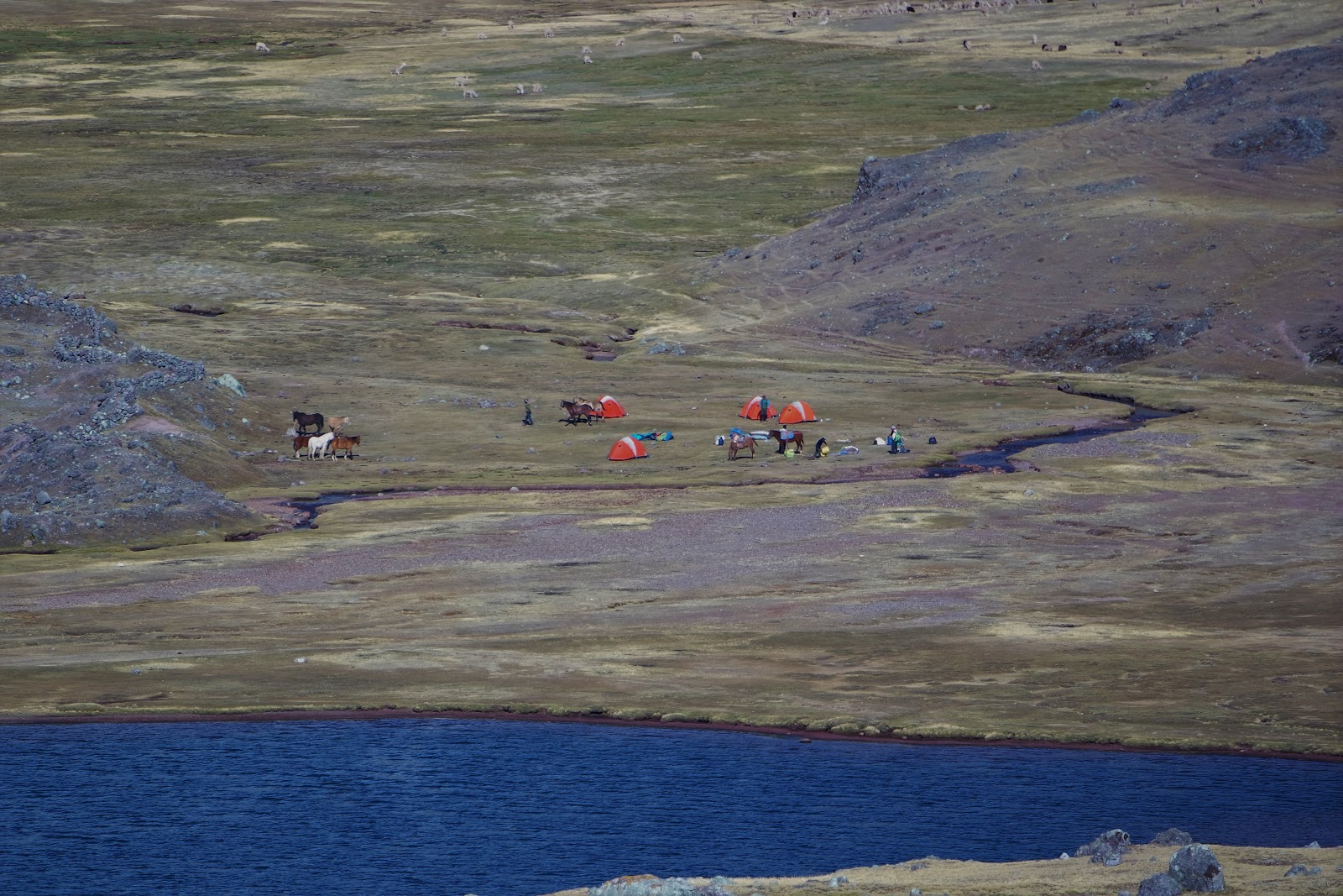
Close up view of camp. There were trout in that lake, but it's a private lake and we aren't allowed to fish in it. It's owned by the local herders.
I shared that one of the things that I have really enjoyed about
living in Juneau is learning about the land. In the past 8 years, I have seen
the glacier recede and the process of the flora taking over the exposed land.
Funnily enough, when I was selling tours in Juneau, I was required to go on the
city tour so I knew what I was selling. And the individual who was the tour
guide used to work at the Forest Service. He explained to all of us why there
were different plants in different locations in Juneau and how it connects to
the glacier receding. That stuck with me, and has made me acutely aware of
different climates and flora as I visit different place. I shared this with Ted
as we were hiking, and he responded saying that the world is like a book, you
just need to understand the language to be able to read it. Like my broken
Spanish, I’m just starting to learn the language.

My tent.

Effy told us that the Milky Way was the primary god of the Incans. For this picture, I just faced the camera straight up and got the mountains on both sides of the Supreme God.

Looking back to camp.


Milky Way falling behind Ausangate.

And a tent-selfie, where I didn't realize I was wearing only one glove. But I only needed one hand for all the buttons on the camera. The good news is that I finally figured out the timer.
In the middle of the night, I woke up to what sounded like a jet
landing or a river raging. And it took me a second to think… we’re not close to an airport. There is a
river, but it’s not a big one. Oh my god, I think that’s an avalanche. And
then I thought about where our campsite was in relation to the glaciers on the
mountains, and thought, I think we’re
alright. There’s a lake at the bottom of the glacier and it wouldn’t cross the
lake and get to us. Plus, the guides would probably be yelling at us if there
was a problem, and they wouldn’t camp in a site that is susceptible to
avalanches.
Day 3: Pucaccocha – Puca Pass – Chillca Valley – Warmisaya Pass –
Yanaccocha Lake
When we woke up, the guides confirmed that there was an avalanche
the previous night, but that it was around the corner of the mountain, and we
couldn’t even see it. I overheard Joseph and Alex commentating on the others
flatulence in the tent, and I jumped in the conversation and said, “Yes! High
Altitude Gas is a thing.” And one of them – I can’t remember which – seemed
thankful to know that it wasn’t him, but that when you get at certain
elevations, it affects your body, and you definitely become a little bit
noisier. And if you’re interested in reading more, it’s actually called High Altitude Flatus Expulsion.
Day 3 was the hardest day, we would be doing two passes, Puca Pass
and Warmisaya Pass. After breakfast, we turned our backs to Ausangate and went
straight up the mountain to Puca Pass at ~16,170 ft. It took about 2 hours to walk
up the hill. Had we been at sea-level, it would have taken 20-30 minutes. Even though I was feeling much stronger than
the first day, the air was still thin. It seemed that we would walk for 5
minutes, and then take a breather for 5 minutes. I’m sure it wasn’t that
contracted, but it we took regular breaks. From camp to the pass was maybe a
mile or two, but straight up hill.
When we departed Puca Pass, we were heading down in to the Chillca
Valley. Up until this point, we were hiking to or skirting around Ausangate.
Ausangate is the highest peak in South America at 21,000 feet. We
were told that the Incans used to worship Ausangate as a god, before the
Spaniards came. The mountain provided water and life to the people that lived
near it. Still, there is an annual festival that draws people to celebrate. The Quecha people who
live around Ausangate are one of the last pastoral communities in the world. While we were walking past the Quechua, one of my
favorite things to see was that wear their traditional clothes regularly. It
isn’t something that is reserved for special occasions. The clothing is still
functional and worn regularly. In South America, the only other pastoral
society is the Aymara of the Andes and Altiplano regions, and in North America,
only the Navajo.

The last schlepp uphill to Puca Pass. You can see all the rocks piled at the pass.

The view to Yanaccocha Lake, where we camped the night before.

You can see the colors starting to show.

Selfie at the pass. After catching my breath.
Next was down in to the Chillca Valley where we started to see the
colors that were prominent on Rainbow Mountain.

Looking back at Ausangate over Puca Pass.

The herders spray paint different colors to mark their alpacas. I'm gonna be honest, I took a lot of pictures of Alpacas, and my favorite thing to say was, "There's some alpaca caca, don't step on it!"

Got a little close to these ones.


Lunch was located at the base of the second pass of the day. One
of the things that I was very cautious about, after the first day, was ensuring
that I didn’t eat too much. I think Effy noticed, because he brought it up. But
not only was I worried about the throbbing headache that I had the first day,
but I also just had a loss of appetite. Another symptom of altitude
sickness.

Parade of llamas with earrings at lunch.
After lunch, we were heading to our second pass of the day
Warmisaya Pass at 16,355 ft. At lunch, Effy said that if we went the long
route, we might see more vicunas, or we could go the short route – straight up.
As we were walking, Effy asked us what we thought, and I reminded him that he
said we could see vicunas if we went the long way. Joseph said, “Oh, thank god
someone said something.” Two passes in a day is exhausting. I was definitely lagging
behind. As we got up a little higher, it got a little windier, and we were in
the shadow of the mountain at the pass. I hate to say it, but I didn’t have
much stamina in the cold, and went and found a place out of the wind and a
little down the path.

Photo looking back to the Chillca Valley just before the Warmisaya Pass. It was very windy and cold.

My "I'm actually really fucking cold and being from Alaska doesn't make a difference" smile.

Looking down to camp at Yanaccocha Lake. You can see our trail down. Effy told us that 3 weeks prior, it was all snow.

The sign at Warmisaya pass announcing we were at 16,355 ft. Torre Estrella is not amused.

Finally out of the wind and at camp.
After Warmisaya pass, it was straight down to camp. That night, we
camped at Yanaccocha Lake. The elevation was less than 16,000, but definitely
in the high 15,000s. At dinner, Effy asked us if we wanted to watch the sunrise
over Rainbow Mountain. I feel that question answers itself, and we all agreed
to do that. That meant we were up at 4 am, no breakfast, and on the trail at 430
am. It takes about 2 hours to get there for a 630 am sunrise. After a few night
photos, it was early to bed.


Meal tent, and the crew quarters.

Day 4: Yanaccocha Lake – Rainbow Mountain (16,508 ft.) – Cusco
At 3:50 a.m., I got my cup of Coca Tea, and had mostly packed the
night before. As we started to hike in the dark, I realized that my headlamp
was terrible, or the batteries were dying. Either way, I was thankful for
having someone behind me with a bright headlamp.
Maybe 30 or 40 minutes in, I started to really lose energy. I kept
drinking water, but I could tell that my body was running low on fuel. Even
though it wasn’t supposed to be a break, I told Effy I needed something to eat,
even just a couple of bites. One of my fellow hikers cheerily, stated that I
just needed more water. But, in fact, it was food I was in need of. (I'm not a morning person, so the exuberance was a bit much for me at that moment.) After
gnawing off two or three bites of a frozen Rx bar, I shoved it in my pocket,
and we kept going.
As it started to get light, there were plenty of places to take
beautiful pictures, but it was dark and cold and we had a sunrise to catch, so
I didn’t stop. I was also the slowest, so stopping would have slowed the group
down even more. When we were just around the corner from Rainbow Mountain, Alex
and Joseph ran the last bit. To the top. Which was at 16,508 feet – the highest
elevation of the entire trip. And they ran. Meanwhile, I was slow and steady
huffing my way up the side of the mountain.
Despite moving slowly, we still made the hike in one hour twenty
minutes. Effy said it was a record.

Every single step the last little bit up the mountain took effort. I have a friend that I go hiking with regularly and she has asthma. It was moments like these I thought of all the hikes we had been on together and how she needed regular stops to catch her breath. The whole week, I kept thinking about her and her struggle with breathing. I could fully empathize with her now. And it's a bizarre feeling knowing that you're breathing normally, the atmosphere is just thinner and you have to go slowly.

This about the spot that Alex and Joseph starting running. Ted and I continued on like the Tortoise rather than the Hare.


Tea and breakfast at 16,508 ft.

The double-selfie! Also, I accidentally left the ISO up way too high and didn't realize that until I loaded the pictures on the computer after getting back.
Then the tourists show up around 8:30/9ish from Cusco and
surrounding areas. Until that point, we had the entire mountain and sunrise for
2 hours to ourselves. Then we walked downhill, while everyone else heaved while heading up.

The final dinner. Oh, and can I tell you how much I scarfed down those tomatoes and cucumbers. I think they just put salt and pepper on it, but I felt like a kid in a candy store and couldn't get enough.

Two gentleman chatting. We camped at the base of the mountain behind them. Rainbow mountain is just to the left, and Ausangate is on the right out of view.
Then we were done hiking. We had lunch, got in the bus, and
started the drive back to Cusco.
Hedy was at the hotel when we got there. Excited to see her, I gave
her a hug, and she gave a gentle encouragement to shower. I asked if it was
that bad, and she replied, “You’ve definitely smelled better.” It was a fair
point considering I had worn the same clothes for 4 days.
At the end, the grand total was 32 miles with the highest
elevation of 16,508 feet. That night, I went to bed in a hotel. and I'm going to be honest, I missed the tent and the sleeping pad.
More pictures of Day 4.
More pictures of Day 4.
--------------------------------------------------------------------------------------------------------------------------
Killa Expeditions is
the company that we went on the trek with. Mama Killa is the moon goddess or
Mother Moon in Incan Mythology. Killa Expeditions did an amazing job with us.
After the trek, we stopped and did the iconic tourist attractions in Peru
including the Salineras at Moray, the Terraces at Moray, and ultimately Machu Picchu.
Killa also does social projects. They are currently in the process of building
a school in the community at Willoc Alto. They prioritize giving back to the
communities that their guests visit on their treks. Instead of paraphrasing, I’ll
steal from their webpage, verbatim:
At Killa Expeditions we are passionate
about giving back to local communities, providing for the families and villages
who let us use their land for trekking and camping, and supporting locally
owned/run businesses. Each year we hold numerous charity events for a variety
of local communities. People living in the mountains do not have access to regular
medical or dental care and often don’t have basic necessities, shoes or proper
clothing. If you would like to help us give back – be it time, money, supplies,
clothing, shoes, medicine, and/or professional expertise (e.g. medical advice,
dentistry, nursing, chiropractic adjustments, etc.) please get in touch to find
out how you can help! In the future, we hope to raise funding and labor to help
build schools at other communities as well as provide various professional
services via volunteers such as a doctor/nurse clinic, chiropractic adjustment,
dental checks, vising and hearing checks and more!
When we were hiking, Effy shared that by building these schools in
the communities, it helps keep families together. A lot of times, kids have to
travel to attend schools on a regular basis. Needless to say, we all found Killa
Expeditions to be an amazing company that hired locally, and the service they
provided was beyond exceptional. It was an amazing trip.