Thursday, May 2, 2019

Hike 20: Ballyhoo, Unalaska - April 8

I grew up in Unalaska, and never climbed Ballyhoo. Fortunately, we were out there for work. 50 min up and 30 min down. 

That hike is straight up the side of the mountain. I started doing my own switchbacks every 10 feet to give my calves a break. And I had one of those moments, and thought to myself, Why the hell am I torturing myself right now? And then I remember one of my favorite quotes that always keeps me going is, If you do what is easy, life will be hard. It's from one of those motivational speakers, and it's something that has stuck with me. And remembering those words is a good reminder that I have to keep going to accomplish my goals. 

This is a short write up, but a few pictures from the hike... 


Sunday, April 28, 2019

Hike 18: Olomana aka 3 peaks, Kailua, HI (March 27)


After completing Moanalua Valley, I asked for a recommendation for another hike from the guide, Mike. He gave me a couple, but the one that stuck with me was Olomana or “3 Peaks” over in Kailua. He said that if I could handle Moanalua, then I would definitely be able to handle Olomana. I hadn’t heard of it, but easily found it on my hiking app, AllTrails.

I rented a car for the day, and ended up getting a later start that I originally planned. I had some gnarly blisters after hiking with wet tennis shoes in Moanalua, so had to stop and get bandaids.

The trailhead is about a half to ¾ of a mile from up private property in a golf course. Google Maps takes you to the trail head, but you’re not actually allowed to drive or park there. I pulled up to the security guard station, and the woman came out and told me I had to “park off the road.” Well, the road was a fairly narrow strip of asphault, with some grass next to it. I turned around, and went to the grass and parked the car there, and went back to the security station to make sure that’s what she meant. She seemed to be irritated with me, and told me again, that I had to “park off the road.” I asked her if that was good enough, to ‘park on the grass,’ but she told me again that it was private property that my vehicle would be towed. I told her that I didn’t want to break the rules, and I just needed to know where to park and I would park there, and she told me, again, to “park off the road.” She said that it was private property, and that I wasn’t allowed to park there. I asked her where I could park, and she informed me that I had to go back. I asked her if I had to go back and park in the neighborhood. And she said to “go out.” I asked, “back past the sign for the golf course.” “Your vehicle will be towed, the whole road is private property.” I called it quits, and drove slowly back to look for places that other vehicles were parked. I drove around for a little bit. A little bit too long, and saw some vehicles parked on some dirt, there were both “off the road” and beyond the sign to the golf course, so hoped that it was a legal place to park and my rental wouldn’t be towed.

Then I walked in. I asked the guard if there was a sign and she nodded and gestured me up the road. I didn’t know if there was a sign, or if she was just tired of talking to another hiker who didn’t get the private property parking protocol, but I walked on.

Fortunately, there was a sign.

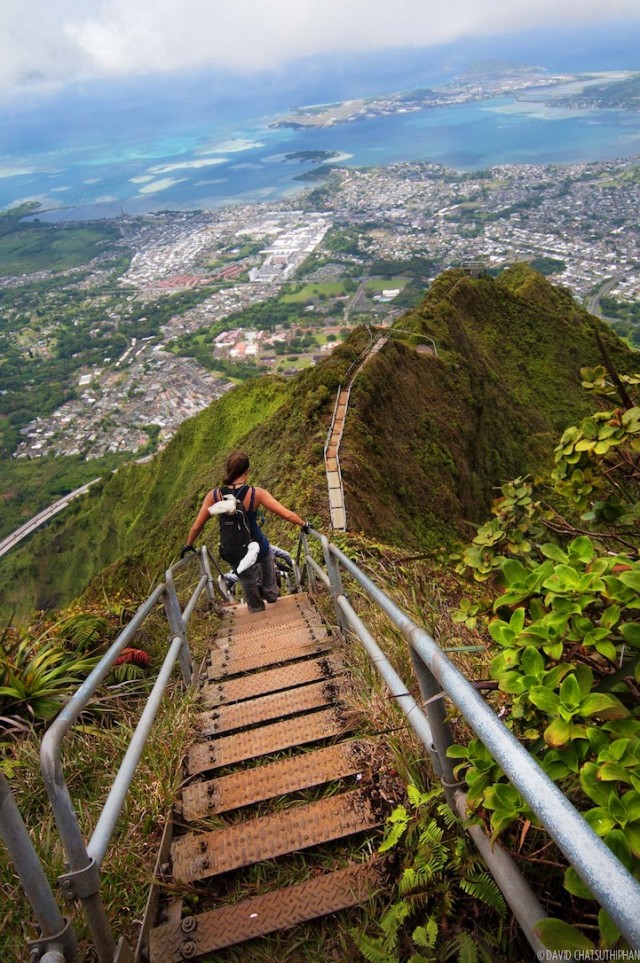
The trail was pretty root-y at the beginning, and fairly quickly, you’re up on a ridge. The views quickly get better, and the trail gets steeper.

Mike told me there were a few rock scrambles and there were, but the first that actually surprised me was a 10-15 foot rock wall (on a ridge) with a 3 different ropes to help you get up. As I was examining the best route up, two other hikers came up behind me. One expressed gratitude that they weren’t the first one’s going up, and could watch someone else go up.


The ledge continues, and eventually you get to another rock scramble, and there’s about a 6-9 inch ledge that your feet can scoot across, while your hands grab rocks, and it is straight down behind you. There are trees and shrubs to catch you if you lose your balance, but you need to catch them as you fall to save yourself.

Everything was dry, and I had spoken to a half a dozen hikers who had already completed the hike for the day, so I kept going. Then I got to the top.


In case you can't tell, that is a ridge, and it drops down on either side. The trail is the little bit off to the left where you have to go down. 


It was a beautiful warm sunny day, until I ate lunch. Then it started to rain.

This wasn’t a light-misty Seattle rain, or a sideways-sting-your-face Dutch Harbor rain, or a moderate Juneau rain. This was a stand-under-a-hose-downpour-tropical-rainforest rain. That morning, I looked at the forecast, and thought, I won’t need my rain jacket. I’ll just shove it to the bottom of my backpack, BECAUSE IT’S ALWAYS GOOD TO HAVE, but I won’t need it today. And, I always have my backpack rain-fly. And I couldn't have been more thankful that I was prepared and didn't take any shortcuts.

That is one of the things that I have learned from hiking and backpacking, is being prepared. Bringing along the things you don’t think you need, you don’t think you’ll use, but you’ll regret not having if you do need them. There have been so many times that I’ve needed something, and haven’t had it. I would rather bring a little extra weight and be prepared than skimp and suffer.

Anyway, this is where the hike went from a fun and exhilarating hike to, “oh shit… am I going to slide off the side of this mountain?” Once again, I had the thought, It’s a good thing that no one knows how bad of a situation I’m in, because they would probably be pissed at me.

So, in reverse order, the first bit of rocks that I need to go down is where I’m essentially hanging off the cliff. The shoes that I’m wearing are supposed to have good traction. They don’t. With every step, I would test whether I had sound footing, and I didn’t always have that. I put a lot more emphasis on ensuring that my hands at strong holds. (Sidenote: I purchased gardening gloves when I purchased bandaids that morning.) I got through it, but the trail was muddy, and the rain was coming down. My feet slid several times, so I was moving slow. Every step, whether on a cliff, a ridge, or the trail, I was moving slowly and trying not to slip.

Then there was the 10-15 ft rock wall. Now, I have to go down. I didn’t have anyone to help coach me on where to put my feet, so I was going down blind. I would try to look, but it’s not always that easy. The short story is that I did it. As I was going down, I wrapped one of the three ropes around my left arm, and that was my primary stabilizer.

I kept going down, and kept going slow. There were several muddy scrambles where I just sat down in the muddy water streams and scooted my butt down, grabbing roots, using my poles to shift weight, and not slip off the side of the mountain.

On one of the muddy scrambles, I did lose my footing and started to slide, unable to stop. But, I had wrapped the rope around my left arm, and thank the moon for strong left arms, because that’s what kept me from sliding any more than a foot. I was able to stop myself, and grab a root and reposition myself to get my feet under me, shift my weight and move to a safe position.

Going down was much harder than going up.

The rain stopped, and the sun came out, and when I got towards the bottom of the mountain, I actually touched the dirt because it looked dry. It felt dry too. I kind of wondered if I had been in the twilight zone of rain.

I got down, and took off my wet gloves and Velcro-ed them to my pack, but still managed to lose one.

After that entire experience, I decided to write off the hike that I was planning on doing later. I looked for the closest target to buy a pair of sandals, because my shoes were soaked, and I needed my feet to dry out.

As I left, the woman who greeted me was driving back and forth on her golf cart, making sure that everyone, “parked off the road.”


Monday, April 15, 2019

Hike 16: Koko Head - Dec 31 & March 27

It's always before a plane.

Jay and I were in Hawaii for Kristin and Peters Wedding, and we had some time to kill on Dec 31 before getting on the terrible red-eye to Anchorage. So, we putzed around Honolulu, ate some donuts, visited Kristin and Peter at work, sang Karaoke, and decided to go for a hike up Koko Head.

Koko head is on the southeastern side of O'ahu. The trail consists of 1,048 rail ties up the side of a mountain. The military put pillbox lookouts at the top of the crater during WWII and the railway was used to haul cargo and supplies to the top. According to another website, you gain approximately .1 ft of elevation for every 2 feet of distance. After .9 miles, your elevation peaks out at 1208 above sea level.

Jay and I gave ourselves a time frame. So we started up in the afternoon. After about 45 minutes, we probably made it up about 2/3-rds of the mountain. But we had to get on a plane and needed to head back towards the airport.

So, we turned around.


--------------------------

In the undocumented and forever uncelebrated life of Monica, this day will always be known as the "Double Hike Day."

I had planned to do two peaks that day, but got a later start than originally planned , so scrapped the idea. And after the difficulty I had on Olomana, I decided that one hike was enough. So, I went for a drive around Makapu'u Point on Oahu, which ultimately had me driving past Koko Head. As I was driving, I couldn't help by stare at Koko Head, and thought to myself... I can do it. I can get it down in the next 2 hours or so.

So, I pulled over to the parking lot, put on my wet socks and wet shoes, emptied the last bit of the water bottle in my camel back and went for it. I was excited to try and climb this mountain that had defeated me before and spurred my desired to come back.

After I had written off doing Koko Head, I was a little sad to walk away from a mountain that had bested me. But the the rational side that said "You really don't have enough time for this and should go take a shower and not push yourself to hard" was overpowered by "When are you going to come back to Honolulu? When are you going to have this opportunity again? This was hike 16, and you didn't finish. You have to finish."

Besides, I could get on the plane sweaty and gross. It wouldn't bother me, just everyone else.

And I did it. It took about 45-50 minutes to get up to the top. Last time, we took about 45 minutes to get 2/3-rds of the way up.

The crater. 


I didn't realize that my hat looked so goofy. It was hot, so I barely had it on my head. 


Coming down took about 30 min, and was as equally difficult. After the first hike, I was a bit tired and having a hard time coming down. At one point, I was awkwardly scooting on my butt throught a part of the trail where the ground is 15-20 feet below the rail ties, and lots of people just came walking casually past me. I looked at one and said, "This is my second hike." I felt like he gave me a look and he continued on.

I made it down, went back to Kristin & Peter's, took a shower, and went to the airport. I fell asleep before the plane took off.


Friday, April 12, 2019

Hike 17: Stairway to Heaven - Moanalua Valley to Ha'iku Stairs - March 25

Me, to me: "Hey Monica, Let's fly to Hawaii to climb up a mud waterfall with a 2000 foot drop on both sides of you. Great idea. Greeeaaattt idea."

This was definitely a moment of self-doubt that led me to wonder if I had made a good decision, or if I would be one of those people you read about in the newspaper and everyone says, "That's darwinism."

I had spoken to several hikers who had turned around at this point because they weren't comfortable. I thought about turning around too, at least 4 times. Especially because it was windy and rainy. My guide told me, "The conditions aren't the best, but I've completed the hike in worse weather." And also, when am I ever going to have another opportunity to do this hike?

There were several times when the wind picked up, and I just hunkered down behind a shrub waiting for it to pass. Funnily enough, it reminded me of being a kid and walking down the driveway in those good-old-Aleutian storms without tree protection, but hunkering down behind one of my dad's many pieces of machinery.

The entire ridge was as wide as a normal sized stairwell, on the widest spots, but with limited protection from the wind the further the hike went. A few times, the wind started to really pick up when I was in one of those spots where there wasn't any protection, I just make sure that every step was deliberate with a strong foundation, and my poles solidly in the mud.

I had to keep reminding myself why I'm here.

In December, Kristin and Peter got married, and we didn't really have time for a big hike like this. This hike was something that I couldn't stop thinking about, so at the end of the wedding, after hardly getting a chance to talk to Kristin and Peter - because of wedding festivities - I decided that I was going to come back and hang out with them, and hike while they were working.

On Sunday night, I was looking at reviews for Stairway to Heaven, planning to do it on Wednesday, and one of the people left a review saying "message me on instagram if you have any questions." Well, I decided to send him a quick message asking a few things. He responded with answers and asked if I was interested in a guided trip. I hadn't planned on it, but thought that it's good to support local people, and this was a trail that I wasn't so sure about. So, Yes. Mike does the hike weekly and charges $75 which includes grippers and gloves. I'm not sure if it's $75 per person or total, because it was just me. And I'll tell you right now, I would not have been able to find the trail nor make it to the top without his services.

He knew the trail and all the offshoots that people get lost on. There was a solo-hiker who went on two offshoots before finding the correct trail up the middle ridge. Ultimately, when I was at the top, that solo hiker teased me for being more french than she, because I brought brie and a wine spritzer for a snack.

Story: The Ha'iku Radio Station was "a top secret facility that was to be used to transmit radio signals to Navy ships that were operating through the Pacific." Apparently, it took the first climbers, Bill Adams and Louis Otto 21 days to figure out the route and to reach the summit. Fortunately, it took me 4 hours, but that's because the trail already existed. And Ha'iku is the name of the area after the Kahili flower, and not the Japanese style of poetry.

So, now for a few pictures: Screenshot of the trail on All Trails, as well as the incline.


On the ridge. With the wonderfully limited view. 

Another ridge photo 

Video of how terribly windy and rainy it was: 

.

Selfie with the trail behind me, and little to see. I did not realize that my gloves were so muddy when I itched my face. Because it was so wet, I took very few photos going up, and did not get a picture of the vertical mud waterfall. 

The mud I was walking in. Without the grippers/Yaktrax, it would not have been possible. I told the guide that I never would have thought to use grippers in the mud, but they are now a new essential to hiking. 

Inside the Haiku Radio facility. Lots a grafiti.  


Found this appropriate: 
Yes, there are two paths you can go down, but there's still time to change the road you're on. -LZ

First time hiking with my new Garmin InReach. I am still learning how to use this thing, and forgot to track my trail until the end when I remembered that was an option. I'll get used to using it more regularly. 


Top of the stairs. 


The Haiku Radio Facility 

And time to head back down the mountain. I took this picture to try and show how narrow the trail was. And I preferred walking in the muddy rut instead of risking slipping on the sides.  


The valley started to clear on the way down, and I could see where I was going instead of a mysterious trail off in to the mist. 


Neat vegetation lining the trail. 

Muddy muddy muddy! 

My hands, AFTER washing them, and wearing gloves. 

Had it not been misty and rainy, this is the view I would've had:

Instead of this: 


However, for fun, I decided to write a Haiku about the Ha'iku stairs.

Two thousand foot drop 
Doubting every choice I've made 
To climb to heaven 


Sources: Wikipedia: Haiku Stairs; That Adventure Life: Stairway to Heaven


And now that we're at the end where no one actually reads to this far, I have to come clean. I did have a guide, kind of. I had someone that was on call for me. All the times that I referenced talking to a guide was when I called him on the phone and did check-ins. He was constantly texting me, and I did rent gear from him. However, I did this hike alone, and it was probably the most terrifying and difficult hike I have ever done.

He was a good guide, and everything else I said about him was true. He gave great directions, I only went down the wrong path twice, and did help others find the right path. When I was worried about weather, I called him.

So, I told the white... or grey, greyish... black lie. I lied. I lied to Kristin so she wouldn't be worried about me. And she had every right to be worried about me. I was worried about me. I doubted my choices, and there were a few times that, even though I was being careful, I started to slide off the muddy ridge. That's the real reason I was so muddy. I just sat down in the mud the mud waterfalls, grabbing to the rocks, ropes, and roots. And then I doubled down so she wouldn't be angry with me. And now I'm telling the truth here with the hopes that she forgives me by the time I see her at the end of May. I am thankful that I have friends who care about me.

Kristin, I'm sorry.

Saturday, December 8, 2018

Hike 14: L'ux/Mt. Edgecumbe, Kruzof Island, Ak (Sept 22)

There's a volcano near Sitka that most people know as Mt. Edgecumbe. I travel to Sitka for work, quite often and on one trip, I mentioned that I was interested in climbing Mt. Edgecumbe. Well, sometimes if you put things out to the universe, the universe finds a way to deliver. I was going over on a Friday and mentioned it to a teacher-friend. She insisted that I had to stay over and we would do the hike on Saturday.

As we were climbing, our guide explained that it's name is actually L'ux or L'ook in TlingitIt is an iconic mountain that quickly identifies itself as a backdrop to the community of Sitka. It received the name, Mt. Edgecumbe when Captain Cook passed through the area in 1778.

L'ook is located on Kruzof Island, near Baranof Island on which Sitka is located. To get there, a water taxi is required. We opted for a teacher-owned water taxi, Tongass Trolls, Tour, & Taxi. So, we were set, at the unholy hour of 630 AM, we met at the harbor to head to Kruzof. That morning, we woke at 530 to throw some muffins in the over and cook some bacon for the 30-ish minute breakfast cruise over to Kruzof. As we were going over in the morning, I realized that it was the first time I had been on the water in the past 4 years of visiting Sitka.


We landed at the cabin and started the hike. It is 7 miles, one way to get to the top of the mountain. It was chilly and the board walk had a thin layer of frost on it. Also, I didn't take out the sweet delicious bacon, and was hiking on an island that has a healthy population of bears. Great idea!

It's fairly flat, with minimal up and down, until the last .7 or .8-ish miles, and then you're heading straight up the side of the volcano. About 3 hours in, and on relatively flat ground, my knee started to hurt. This has been an on-going problem, and my physical therapist has told me what to do for it, but I haven't been doing it. I am the only person who can do anything about it, but I keep not doing that one thing to fix my problem. And I'm reminded of my lack of effort to fix that problem when I'm doing something that I want. So, now that I'm in the middle of a hike, I can't complain, because it's my own fault, and I've only got myself to blame. Which is a frustrating thing.

After leaving the trees, that's when you start to enter another world. The trees end, and the tundra starts. There is a pretty notable rut where the trail goes up with markers. The sign says to only follow the markers in the fog because the ruts will be exasperated by repeated treading.


The ruts were bits of pumice. Pumice is a very light rock. And it was weird to be walking up the side of a mountain with light-weight and tan colored stones sliding around your feet. The pumice pebbles were as sand-like in that the pebbles were loose and falling around your feet and not solid - unless you went over to the tundra/lichen that grew on top of the pumice. The last bit of the hike was a pretty consistent incline. And then you get to the top, and it feels like you're on mars.


Hiking companions. 

It was also a beautiful sunny day. Almost painfully sunny.


We decided to hike around the rim. On the northern side, we stopped and had lunch. The day started cold and with frost on the trail, and it never really warmed up. When we were out of wind and in the sun, I warmed up a bit, but not much. Up on the rim of the volcano, it cooled back down and I was wearing as many layers as I had. I was thankful for the lunch break, because my knee was really starting to get to me and I was starting to slow down.


And then, we started to come down the Volcano. At the risk of pouring lava (volcano joke) on the horse that is already in the middle of this blog, my knee really fucking hurt and I was having a really hard time coming down that mountain. A few times, I sat down and just starting sliding down to try and catch up, but that didn't help much. My hiking partners still had to wait for me. I was definitely the slow person.

Fortunately, not only does everyone in Sitka know each other, but everyone who decided to hike L'ux that day knew each other as well. One of the individuals worked at the hospital and was smart enough to bring drugs. I have never been more shameless about talking to strangers with drugs in my life. He had ibuprofen and aspirin, and I took the maximum he allowed me to take. I should know better. And that's another one of those lessons I learn the hard way - TAKE DRUGS ON HIKES - drugs like ibuprofen or aleve or tylenol.

That hike down was a really good reminder that if I'm going to keep doing this project, or simply be a healthy active human being that plays outside, I really need to do the exercises my physical therapist told me to do.

And then we got on the boat and went back to find Sitka in a power outage. I took a quick shower and went to the airport to fly home.

The trail on the way out. 


At the end of the day, it was a 15 mile hike for about 10 hours and peak elevation of 3202 ft. After, I realized that is the longest I've ever done on a day hike, and stupidest because I carried bacon in bear country.

--------------------------------------------------------------------------------------------------------------------------
As a bonus, I took a few night pictures the evening before the hike. I've been having fun going out and taking night photos and am still learning the settings on the camera and the best way to capture these images.

A very bright moon-set. 

The last glimpse of the moon. 

Looking north to the mountain.